Cap de Creus lighthouse - Port de la Selva - Llançà

 Day 1. Thursday 16th August 2012.
We set out from Cap de Creus lighthouse at 7.15h on Thursday morning, quite a bit later than I had expected. It was going to be an extremely hot day and this first stage of the crossing had little or practically no shady areas. Little did I know then that I had chosen the hottest week of the year to do this walk.
At the start there are a lot of red and white GR 11 markings, which can be quite confusing. I found that it was better to go onto the road after passing the lighthouse and restaurants and walk those first 3 kms along the road. They are clearly marked 1....2....3, and on completing the 3rd kilometre, you take a right turn off the road and continue following the GR 11 markings. Shortly after coming off the road, there is a signpost for El Port de la Selva (14 kms) . From here on to El Port de la Selva the trail is easy to follow and the markings are very clear.
We were able to find some kind of shade under the odd pine tree, which rather surprised me as I was under the impression that trees were practically non-existent along this part of the walk. I was wrong but delighted at the same time and soon discovered that shade and water would be what I cherish most over the forthcoming days.


 After contemplating San Pere de Rodes for 15 or 20 minutes we made our way to the other end of town to start the 500 metre climb to the monastery.It was neither the best time of the day or year to carry out such a task but there was no turning back now. It was as I had imagined, the hardest part of the day's walk and both Bronagh and I were suffering the effects of the intense heat. There was no shade whatsoever most of the way up! It's necessary to walk along the road for a while but then later you can take a path that cuts up across the main road at different points and is much more interesting. Along this path we have the opportunity to take in some spectacular views of Port de la Selva as we slowly leave it behind. We also get the chance to see the megalithic monuments, Mores Altes 11 and Mores Altes 1(see photo).
 We eventually came face to face with the impressive Sant Pere de Rodes monastery around 15.45h. At the crossroads near the monastery car park we picked up the trail to Llançà, which is clearly signposted. The GR 11 markings are also clearly visible. From this point onwards it's all downhill to Llançà, which is hard-going on the knees and ankles! The downhill trail is quite gradual at first but then later turns into a narrow, stony path that is quite steep at times. Nevertheless, Llançà came into view soon enough and it wouldn`t be too long before we finished our first day's walk.

La Jonquera - La Vajol - Maçanet de Cabrenys
Day 2. Sunday 19th August 2012.
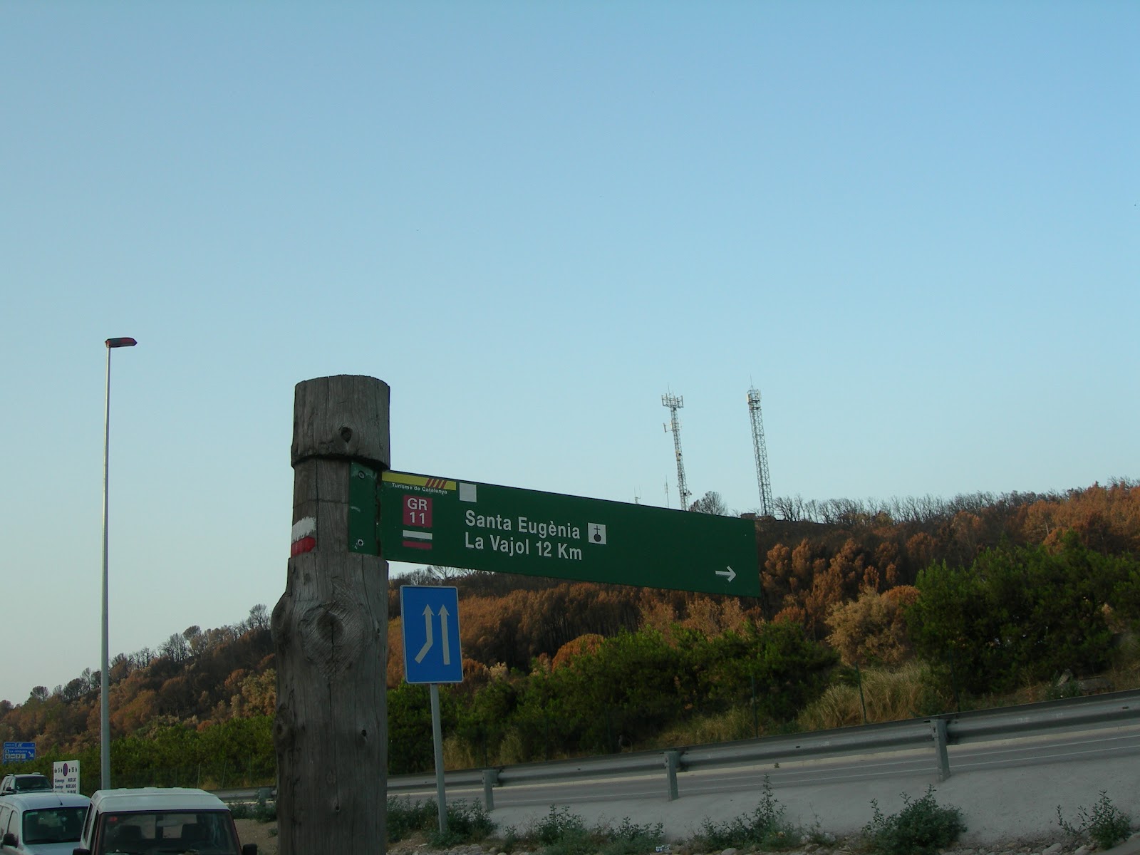
 I set out from La Jonquera around 7.45h on what was going to be yet another scorching hot day. The GR 11 starts in Plaça del Sol and goes down Carrer del Migdía, turns into carrer Major and continues along this street for a few hundred metres. It turns left into Avinguda Miguel Mateu Pla in the direction of the motorway (AP-7) and after about 70 or 80 mts you come across a GR 11 signpost for La Vajol (12 km) and Sta Eugenia. Here you take the tunnel that goes under the National road (N-11) and the motorway (AP-7) and gradually leave La Jonquera behind you.
The scene around La Jonquera is quite horrific due to the terrible forest fires in July 2012. The view of charred trees and mountainsides all around the town is in itself a terrible scar that will take some time to heal. As I slowly moved away from the town, I was completely surrounded by a most disheartening scene as well as the continuous smell of burnt life all around me. This is the scene for the first part of the walk after leaving La Jonquera. No kind of animal life to be seen or heard all round!

 On entering the areas of the forest that escaped the terrible effects of the fire, you can get a clear idea of the beauty that was lost among the flames. The welcoming sound of chirping birds along with the vision of colourful butterflies and the odd dragonfly is an experience you cherish even more after the devastating scenes witnessed just before. Most of the way between La Jonquera and La Vajol is along a dirt track, which eventually joins the road to La Vajol about 3km from the town. This last stretch is uphill along the road for those last few kilometres, unless I missed a GR trail coming off the road somewhere on the way up.
Before reaching La Vajol, I decided to stop off at a rural farmhouse where I was welcomed by the owners, Esperanza and Joaquín who live in the same neighbourhood as me in Barcelona.They kindly invited me to coffee out in the garden where we chatted and admired the spectacular views of Alt Empordà right down to the sea.
 After refilling my canteen and a more than pleasant rest in wonderful company, I set out from this beautiful paradise and reached La Vajol (see photo below left) in about 20-30 minutes. The GR 11 is signposted on leaving La Vajol(see photo below right) and almost immediately afterwards on the left is the famous viewpoint of Alt Empordà (Mirador de l'Empordà). After about 20 minutes or so we reach Mina Canta o d'En Negrín where talcum powder was produced in the past. However, this mine is not famous for its mining past but because it was used by the President of the Spanish Republic (1937-1939, Juan Negrín to hide paintings from El Museo del Prado and gold from El Banco de España, valued at five hundred million dollars and which was later shipped to Mexico.
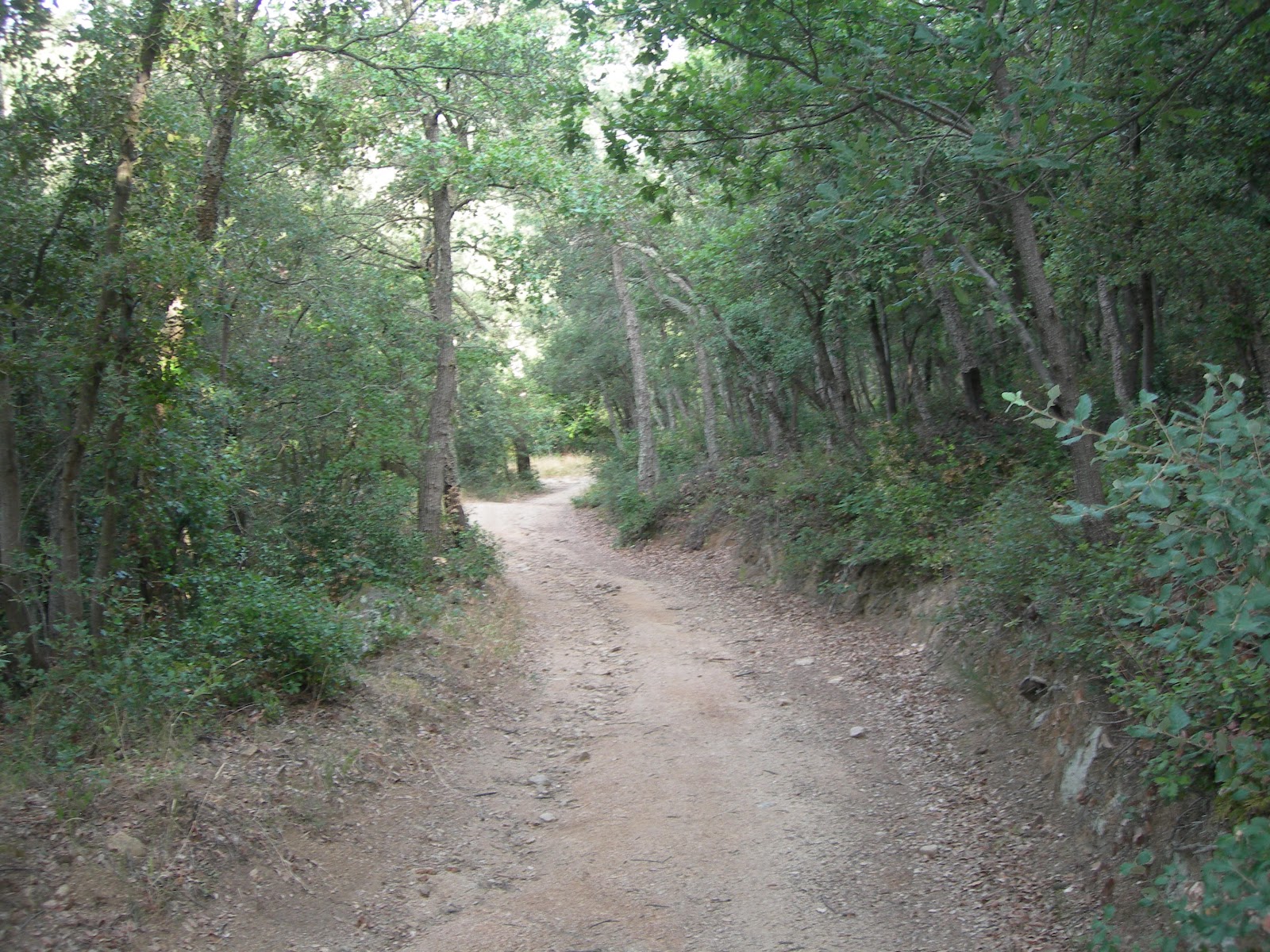
 A lot of the scenery along the way
 to Maçanet de Cabrenys is really breathtaking, especially when the track becomes a narrow winding path through a forest of holm oak and pine trees. I decided to stop here and have a bite to eat. In this way I was able to appreciate the spectacular scenery all around me and the view down into the valley. At this time I was about an hour and a half away from Maçanet de Cabrenys. In fact, I was able to see it in the distance a couple of times along the way.

 I reached Maçanet de Cabrenys just before 18h. The GR 11 comes out onto the main road just about 10 minutes before reaching the village. The last part of the walk is through a row of banana trees on each side of the main road into Maçanet de Cabrenys. I had just finished day 2 of the walk feeling very tired and thirsty but nevertheless, an extremely satisfied man.
Maçanet de Cabrenys - Albanyà
Day 3. Monday 20th August 2012.I left Maçanet de Cabrenys around 8h on what was going to be yet another scorcher of a day. However, there was a lot more shade in this part of the country than what I had had on the first day of the walk with Bronagh.
The GR 11 goes out of the town along Carrer Casanova, which branches off to the left just as you are entering Maçanet de Cabrenys. You walk through a housing estate before eventually taking a track out into the country. The GR markings are easy to follow and well and truly visible.
 Here I would like to give a wholehearted thank you to those people who go round marking the trails. Without their help, some people like me wouldn`t be able to fulfil some of our dreams. Thank you!
  At times it's quite easy to lose your bearings and take the wrong track. This happened to me on at least 3 occasions. There is so much beauty out there that it is only normal for your senses to go into raptures from time to time, thus causing you to be totally absorbed by what is all around you. That delicious feeling of being happily lost! More than once I had to backtrack for close to an hour before picking up the trail again. Ah well, the unpredictable is all part of the adventure!
Not long after leaving Maçanet de Cabrenys, I was so busy taking in all that lovely surrounding countryside that I took the wrong trail. However, this particular time there was a farmer at hand who was able to send me in the right direction. He was ploughing his field and on seeing me going what he thought was the wrong way, blew the horn of his tractor to attract my attention and sent me in the right direction. At this point the track became a narrow rocky path as I moved slowly downwards.

 In just less than an hour after leaving Maçanet de Cabrenys I reached Molí d`en Robert, an old mill converted into a restaurant, which is open on holidays and in summer. Once again the GR 11 becomes a track as we start the first uphill climb towards Sant Andreu d'Oliveda, a Romanesque chapel,and then later another uphill climb to La Trilla. On the way up we pass Font del Rimaló, where I topped up my water bottle, and then later Mas Rimaló. From La Trilla on to Albanyà it's a downhill trek almost all the way.
..jpg) About 5 km before reaching Albanyà we pass San Feliu de Carbonils, another Romanesque chapel . After finding a nice shady spot, I decided to have a rest just in front of the chapel. This would be my last stop before reaching Albanyà.
About 5 km before reaching Albanyà we pass San Feliu de Carbonils, another Romanesque chapel . After finding a nice shady spot, I decided to have a rest just in front of the chapel. This would be my last stop before reaching Albanyà.

I eventually reached Albanyà around 15h and quickly found a small bar-restaurant where I enjoyed a nice cool shandy. I thought this would be a nice place to have dinner that evening but later discovered that it closed in the evenings. The only other alternative was the camping site restaurant just outside the village. Anyway, what was most important at that moment was that I had arrived in Albanyà still in one piece and I had completed another stage of the GR 11.

Albanyà - Sant Aniol d'Aguja- Sadernes

 Day 4. Tuesday 21st August 2012.
I left Albanyà around 8h and followed the GR 11 markings in the direction of the camping site, Bassegoda Park. It was another extremely hot morning and I knew that it was going to be a long hard climb to Coll de Bassegoda as well as a sweaty one. Not long after passing the camping site we start the climb along a narrow surfaced road for quite a while, which later turns into a dirt track. The climb is close to 1,000 mt so some of the views of Alta Garrotxa on the way up are absolutely breathtaking!

 About 10h I reached Can Nou, which looks somewhat like a hamlet and where there is a bar that serves minerals and coffee. I decided to have an orange drink to quench my thirst and save my water for later on. I became engrossed in conversation with the little old lady who ran the place and some French people who were drinking coffee. Meanwhile, some hens strutted about the yard pecking all round them. It was a pleasant break in a friendly atmosphere. After about 20 minutes I decided that it was time to continue my journey so I bid them farewell and was on my way again in no time. I continued along the track without realizing that the GR 11 turned sharply to the right and on up the mountainside. Once again I was so mesmerized by all that beauty around me that my orienteering skills deserted me for a moment. Nevertheless, this gave me the opportunity to pay a quick visit to San Miguel de Bassegoda chapel and at the same time take in all the spectacular surrounding scenery, which more than compensated for my lapse of concentration earlier.
 Just around 11h I reached Coll de Bassegoda (1,105 m) before beginning my descent to Sant Aniol d'Aguja, which was still another 3 hours away. The peak itself (Puig de Bassegoda) is another 268 m above. In the end I had taken the long way round to get to Bassegoda, but my uphill climb had come to an end for today and it was all downhill now to Sant Aniol d'Aguja.
 The path down to Sant Aniol d'Aguja is a narrow pathway shaded by beech trees most of the way down. This was to my great joy and relief, especially after the
hot climb to Coll de Bassegoda in the intense heat. Once again the scenery all around is absolutely spectacular and stoppages become more frequent, not necessarily because tiredness is setting in but mainly because one just has to stop to be able to appreciate what is all around him. I felt so privileged to be able to form a part of all this......the views, the smells, the sounds, the silence! Simply, Nature at her mightiest!


I reached Sant Aniol d'Aguja around 14.15h, welcomed by the pleasant sight and sound of gushing water coming from the fountain. It was such a wonderful relief to me as my canteen was near about empty. I gladly drank the cool refreshing water directly from the fountain before refilling my water bottle.

 As I had already decided to go on down to Sadernes instead of continuing to Oix, I took a good 20-minute rest at the fountain before setting off again. These were 20 minutes of pure bliss as I was entertained by the sound of the water sprouting from the fountain and as well as the continuous flow of the river Aniol below. I still had at least another 2-hour walk before reaching Sadernes.
 The first hour or so of the walk after leaving Sant Aniol d'Aguja is alongside the river, so any sound other than that of the gurgling, gushing water is totally pushed into the background. It's a narrow rocky pathway that continuously rises and falls right beside the river, tempting you now and then to plunge into that irresistible water. Somehow I managed to control myself and resist temptation more than once.
The last part of the walk down to Sadernes is along a dirt track, especially once you cross over Pont de San Valentí (a beautiful Romanesque bridge). In fact, this part of the track is open to traffic at different times and there are small parking areas on the way down to Sadernes.
Just as I was arriving at Camping Masia Sadernes I noticed the police had set up some type of roadblock.They told me that they were stopping people from going up the mountains because of the high-risk of forest fires in that area, mainly due to the high temperature and lack of rain. Little did it dawn on me at that moment that this would also effect me the following day and therefore prevent me from continuing the GR 11 from Sant Aniol d'Aguja to Beget.
I arrived at Camping Masia Sadernes around 17h only to discover that the only accomodation there was at the Camping site. After explaining to them what I was doing, they kindly agreed to rent me a small tent and threw in a mattress for good measure. All I needed now was a substantial dinner and a good night's rest to make me one of the happiest men in the world........and happily it worked out exactly that way!
Sadernes - Oix - Beget
Day 5. Wednesday 22nd August 2012.I started out really early from Sadernes, having already decided that this would be my last day's walk this time round. The venture would come to a halt in Beget and hopefully I would be back in autumn this year or spring 2013 to continue my journey westwards. This experience had been so rewarding and I felt extremely fortunate to have had this wonderful opportunity to rub shoulders with Nature in depth.

 On leaving Sadernes I was immediately stopped by the police who explained that they were cutting off all the routes up to the mountains due to the high risk of forest fires. They immediately got out their maps and suggested taking the GR 1 to Oix and then make my way from there to Beget.The GR 1 crosses Spain from Empuries, Girona to Finisterre in A Coruña and goes parallel to the GR 11. To pick up the GR 1, I had to take the main road out of Sadernes for a few kilometres and then just after a parking area on the right hand side of the road, take a track up the mountain. In fact, it's all uphill for the first 3 hours or so but once again the views are really spectacular. The first part of the walk is a narrow rocky pathway which further up the mountain comes out onto a track.
 The GR 1 red and white markings are quite clear most of the time but not quite as clear as the markings for the GR 11, especially as you get closer to Oix.
 After about a 3-hour uphill trek I finally got to the top where I could appreciate some breathtaking views of Alt Garrotxa. From here on to Oix it would be all downhill. In fact, I could just about see Oix in the valley below. Nevertheless, I still had another hour or so to walk before I would reach Oix.
I think these last 5 days that I have been walking have been the thirstiest I have ever spent in my life. I have been averaging between 4 and 5 litres of water a day.They have also been among the most enjoyable I have ever had despite the exhaustion and the sores on my back caused by the friction of the rucksack.

 Just as I was about 30 minutes or so from Oix, I completely lost track of the GR markings and in order to get to the road I had to cross a farmer's field that had been recently ploughed. I was now on the main road into Oix and at this stage I was already thinking about the shandy I was going to enjoy shortly. This had become my favourite drink over the last few days as well as being my reward.
I arrived in Oix about 12.30h, sweating profusely because of the intense heat as well as the effort. I had had quite a bit of shade along the way until the last stretch from the farmer's field to the town itself. Still, I was a really happy man and soon found a bar where I would enjoy a well deserved reward; a large shandy!
I eventually made it to Beget, but that is another story which I will tell some other time. Anyway, I still have to go back to do the 2 stages I missed due to the mishap with Bronagh: Llançà - Espolla/Vilamaniscle - La Jonquera. I also have to return to Sadernes to do the stage from Sant Aniol d'Aguja to Beget, which I missed as the police diverted me on account of the high risk of forest fires in that area. I reached Beget by taking the GR 1 to Oix and from there to Beget.

 I couldn't have finished this first part of the crossing in a more beautiful place. Beget is one of the nicest villages I have seen here in Catalonia. In fact, I think it's one of the most beautiful villages I ever been in. It has a certain magic about it....with its cobble-stoned streets and beautiful, quaint houses with wooden balconies. The continuous sound of gushing water from the nearby river is such a confort to the ears!
I spent a relaxing day and a half here before being picked up by a friend and taken back to Barcelona. In one way I felt a little sad leaving such a beautiful place, but deep down I knew that I would be back at some stage in the not too distant future to continue my expedition westwards. This very thought made me feel better and I couldn't think of a nicer place to start out from than that lovely village called Beget.
Llançà - Espolla
Saturday 22nd June 2013.
I set out from Llançà at around 6.40h and made my way from the hostal to pick up the GR 11 trail just across the road from the Tourist Information office. It's well marked as well as signposted and easy to find. The first part of the walk is a slow but steady climb to Coll de los Portes before you start descending to La Riera de Valleta and passing close to the hermitage, Sant Silvestre de Valleta.


 Just before descending to La Riera de Valleta you have to look back several times at the spectacular views down to the Mediterranean Sea. Here you have one of your last chances to bid farewell to the Mediterranean before heading on westwards towards the Atlantic Ocean.
 From Sant Silvestre we slowly make our way to Coll de la Serra. The first part is a narrow steep path which comes out onto a track around Coll de la Serra. From here we have a marvellous panoramic view for kilometres around as well as a magnificent view of Vilamaniscle. I arrived in Vilamaniscle around 9h and entered the town along Calle de la Tamontana. I left the town along the road to Sant Quirze de Colera, which is signposted. The walk between Vilamaniscle and Sant Quirze is along the road practically all the way,which can be a little boring at times. It's about 6km from the town to the monastery. Just a few hundred metres before reaching the monastery, the road turns into a dirt track. I reached Sant Quirze de Colera about 10.35h but didn't hang around too long as it was getting hotter by the minute. The sooner I reached my destination, the better! About a hundred metres or so before reaching the monastery the GR 11 veers off to the left and you slowly start the climb up to Coll de Plaja. You pick up a steep narrow path up the mountain slowly leaving Sant Quirze de Colera behind you. If you care to look back now and then, you get some great views of the monastery.This narrow path eventually comes out onto a track just before you start the descent to Mas d'en Pils and on to Masía Corbera. From here on to Espolla is around 5km along the road.
 For those of you who need a rest at this stage, Espolla is a good choice and Can Salas is an excellent Rural house where any traveller will be treated with kindness. I arrived in Espolla a tired and thirsty man about 14h but very quickly found one of the few bars in the town where I cherished a large shandy before checking in at Can Salas.
Beget - Molló - Setcases

 Saturday 17th August 2013
07.00h. Well, I really thought I would be on my way by now but there is a spectacular thunder storm right overhead at the moment and the rain is just torrential.

08.30h.The thunder storm and rain seem to have eased off so I'm on my way. Once again I feel sad leaving this beautiful place but I know now and at the same time feel certain that I will come back from time to time!


 You can find the trail to Molló and Setcases right beside the car park. It's very well signposted! The trail goes through a beech tree forest and parallel to the river for some time, so you are accompanied by the gurgling sound of the water, always such a pleasant sound! I thoroughly enjoyed this part of the walk even though I was absolutely soaked to the skin due to the lush and wet vegetation caused by the heavy rainfall earlier in the morning. Nevertheless, I was too absorbed in the surrounding sounds and smells to be worried about my wet clothes.
You have to cross the road a number of times on the way to Molló. I think I counted four! I passed the turn off to Rocabruna and then later Molino de Sorolla, Can Planes and after that Casa Etxalde before continuing the ascent to collado de la Boixeda.

 I arrived in Molló around 12.30h or so under a very dark looking sky. In fact, I could hear the claps of thunder getting louder as I walked through part of Molló. I left Molló along Calle Setcases and headed towards a very bleak looking Collada de la Fembra Morta. I had contemplated the idea of staying in Molló due to the oncoming weather conditions but decided to continue without realizing at that moment that I would be caught in 2 thunder storms before reaching Setcases.
 Thunder storms in the Pyrenees usually start around 15 or 16h so if you are walking in August or September, it's always advisable to get a really early start and try to get to your destination before this time. It's not a pleasant experience to be caught in a thunder storm up the mountains, believe me! The reason I got caught out today is because I left Beget 2 hours later than scheduled this morning due to a heavy thunder storm. An exception to the rule?

Around Coll de Lliens I came across a herd of horses that decided to follow me for a few minutes. The path became a little confusing around here and I really had to keep my eyes peeled. Obviously the horses and cattle have created a series of paths going in different directions and it took me a while to find the Gr 11 markings. Around this time the second thunder storm was quickly approaching but at this stage I was less than an hour away from Setcases so I just kept walking. This last part of the walk is along a narrow path through a pine tree forest until you come out onto a track which takes you down to Setcases. You cross over the river Ter just before you enter the town. It was just after 17h when I got there and I was already looking for a bar where I could treat myself to a well deserved shandy!

Setcases - Vall de Nuria
Sunday 18th August 2013

 Today's stage is said to be one of the most spectacular stages of all the GR 11 as most of the walk is above 2500 metres and many of the views are just breathtaking! I set out from Setcases (1,265 m.) under a magnificent blue sky at 07.15h on Saturday morning. The temperature was 10 degrees centigrade according to the local thermometer, which was quite low on account of the heavy rainfall the previous day. Nevertheless, it would increase during the day and make the climb up to Coll de la Marrana that little bit harder later on in the morning.
 The first part of the walk is along the road for about 4 km in the direction of the ski-station, Vallter. On coming to what is probably the sharpest bend since leaving Setcases, you take a track off to the left that takes you on up the mountain alongside the river Ter. This track eventually takes you back onto the main road further up. You go past car park near the ski station and continue along the road for a while until you pick up a path off to the left of the road. This path takes you on up to the new Ulldeter shelter (2,221 m.), which was built in 1959. The old Ulldeter was the first mountain shelter (1909) built in Catalonia and Spain. However, it is now in ruins and what is left of it is at an altitude of 2,393 m.
 From here it's a slow, steady climb up to Coll de la Marrana. I was surprised to see so many people walking up to Coll de la Marrana but I think this walk from the shelter is quite a classic today. Also being a Sunday in the month of August was probably the reason why there were so many trekkers about. On the way up, you have to stop every once in a while to take in the spectacular scenery as well as a breather!


 It was around 11.45h when I got to Coll de la Marrana (2,520 m.) I spent 5 or 10 minutes here to appreciate the surrounding views as well as catch my breath before continuing my trek in the direction of Vall de Nuria. I had been walking for 4 and a half hours and I still had over 3 hours walking ahead of me but I was enjoying every minute of it.
 The first couple of kilometres or so after leaving Coll de la Marrana are a gradual descent which is a real treat, especially after the continuous hard climb up to Coll de la Marrana from Setcases. Nevertheless, the even harder climb up to Coll de Tirapits (2,791 m.) comes about soon enough and from there on to Coll Superior de la Vaca (2,824 m.). From this point you have one of the most breathtaking views you could possibly imagine, especially the view of Vall de Carançà and the lakes. From here we move on to Coll de Noucreus (2,799 m.), with 9 crosses in memory of the 9 pilgrims who were trapped by a "torb", which is the Catalan for blizzard. Shortly afterwards we start our long descent to Vall de Nuria.......and believe me, it is a long and steep descent! In some parts it's hard going on the knees but bearable.I arrived in Nuria around 16.30h or so and had a good look around to satisfy my curiosity before heading on upwards again to Pic de l'Aliga where I had a reservation for the night. I was tired and really looking forward to a good night's rest before setting off for Planoles the following morning.
Vall de Nuria - Queralps - Planoles
Monday 19th August 2013

After a most substantial breakfast, I set out from Pic de l'Aliga around 7.30h and was down the hill and beside the lake in around 10 minutes. I picked up the GR11 trail on the other side of the lake and headed in a south eastern direction towards the town of Queralps. This path down to Queralps is a real delight and was the route used by pilgrims in days gone by. Today you are accompanied by the gushing downhill river as well as the coming and going of the Rack train (la cremallera, which was inaugurated in 1931 and connects Ribes de Freser and Nuria Sanctuary). Some of the views on the way down are quite breathtaking, so stopping from time to time to absorb what is around you is a must! The GR11 from Nuria to Queralps is a narrow path practically all the way down except for the

 last stretch of road. Queralps is a charming little town which has maintained the traditional Pyrenean architecture with its typical town houses made of stone and wood. San Jaume church is a splendid example of romanesque architecture, especially its pórtico.
 |
| San Jaume church, Queralps. |


 We pick up the GR11 again just behind the church and start a slow but gradual ascent towards San Sebastian hermitage and then on towards la Font de l'Home Mort. In fact, the path is a continuous ascent until we reach Collet de les Barranques where we change mountainsides and gradually start our descent to Planoles. The path down to Planoles is most pleasant as we have the generous shade of the pine trees practically all the way down. On the way down to Planoles the GR 11 path crosses the zigzagging mountain road a few times. We pass by Corral Blanc shelter where we can take a breather or spend the night if necessary. There is also a picnic área. I arrived in Planoles around 14.30h a sweaty and tired looking man. Nevertheless, a nice cool shandy(my personal reward) in the first bar I came across soon gave me a second wind! To round the day, it so happened that this was the bar of the hotel where I had my reservation. All I needed now was a nice shower, some nourishment and a siesta to make it a perfect day.............and so it was!
 |
| Planoles in the distance. |
Planoles - Puigcerdà
Sunday 17th August 2014

 I set out from Planoles around 7.30h on a cool cloudy Sunday morning. In fact, I picked up the track in Planes, which is a little village right beside Planoles. The GR 11 is signposted on the N-152 within a stone's throw of Bar Restaurant, La Carretera, km 128. From this point it's a slow gradual climb along a track for some time before it eventually turns into a narrow pathway. Once I was on this narrow path, I had to stop several times to take in the spectacular surrounding views and at the same time feel so fortunate to be able to witness such perfect beauty! Just before reaching Dòrria the pathway comes out onto a track, along which you enter the beautiful village of Dòrria. This village was declared "Bien de Interés Cultural", which means something like Heritage of Cultural Interest.


 Dòrria is the last village in El Ripollés before entering La Cerdanya. It is also the highest village in Catalonia at an altitude of 1,550 mt. You leave Dòrria by taking a track at the other end of the village. It takes just over a couple of hours to reach Coll de la Creu de Maians (2,000 mt). The ascent is very gradual and along a track most of the way up. This is the highest point along this stage of the walk. From here we go on to Coll Marcer (1,980 mt) before starting our descent to Puigcerdà. From Coll Marcer on down to Puigcerdà takes about another couple of hours or so and most of this is along a track as well as being downhill! My poor knees!
 Once we get down into the valley, the first town we come across is Vilallobent and around 20 minutes later we reach Age.
However, we don't actually go through Age but turn left onto the main road in the direction of Puigcerdà leaving the town of Age over to our right. From here to Puigcerdà is just another kilometre along the main road! At this stage I was already thinking of my well deserved shandy on arrival in Puigcerdà. It was only a question of time; very little time!

No hay comentarios:
Publicar un comentario